
Length: 447.79 miles
West Endpoint:
East Endpoint:
Counties Passed through: Hamilton, Kearney, Finney, Gray, Ford, Edwards, Stafford, Reno, Harvey, Marion, Chase, Lyon, Coffey, Osage, Franklin, Douglas, Miami, Johnson
History
Average Annual Daily Traffic
Junction Guide
West Endpoint:
Colorado State Line west of Coolidge
East Endpoint:
Missouri State Line in Leawood
Counties Passed through: Hamilton, Kearney, Finney, Gray, Ford, Edwards, Stafford, Reno, Harvey, Marion, Chase, Lyon, Coffey, Osage, Franklin, Douglas, Miami, Johnson
History
Average Annual Daily Traffic
Junction Guide
Photos
Clicking on a photograph takes you to the photo's flickr page
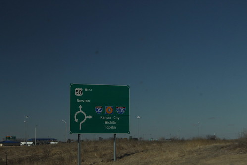
This diagrammatic sign is on westbound US 50 on the west side of Emporia approaching the junction with I-35 and I-335. Note that there are three control cities - Kansas City via I-35 north, Wichita via I-35/Kansas Turnpike south, and Topeka via I-335/Kansas Turnpike north. 26 February 2015
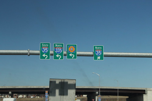
On the connector roadway between I-35 and US 50 on the west side of Emporia is an overhead gantry. These are the signs heading toward I-35 and the Kansas Turnpike/I-335. 26 February 2015