West Endpoint: Colorado State Line near Kanorado
East Endpoint: Junction US 40/US 40S, Manhattan
Counties Served:
Sherman, Thomas, Sheridan, Graham, Rooks, Osbourn, Mitchell, Cloud, Clay, Riley
History
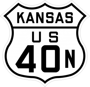
US 40N was designated along the Midland Trail through Goodland, Colby, Hill City, Osborne, and Clay Center before joining the Victory Highway (US 40S) at Manhattan.
The only segment of the Midland Trail to be paved before 1926 was the Beloit-Asherville Road, which was paved between 1921 and 1923
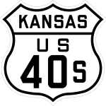
The Original 1925 highway numbering plan called for the Midland Trail to be US 40, but the towns along the Victory Highway protested, claiming that the Midland Trail got the US 40 designation because it passed through the hometown of the Highway Commissioner. A meeting was held with the Victory Highway cities on December 18, 1925, leading to a compromise where the Victory Highway became US 40S, and the Midland Trail became US 40N.
US 40N was re-designated as an extension of US 24 in 1936.
Timeline
- 1921: Beloit-Asherville Road paved from 4 miles east of Beloit through Asherville to the Mitchell/Cloud County line.
- 1923: Beloit-Asherville Road paved near the east city limits of Beloit.
- 1924: The White Way graded from Tasco east 4 miles.
- 1925:
- Victory Highway graded from Colby east two miles.
- Short stretch of the Midland Trail paved just west of Manhattan
- 1926:
- Graded from Goodland east 15.8 miles
- Graded from 4 miles east of the Sherman/Thomas county line to Colby
- Graded from 7 miles west of Clay Center to 5 miles west of Clay Center.
- 1927:
- Graded from the Kansas/Colorado line east to Ruleton.
- Graveled from 4 miles east of the Sherman/Thomas County line east to Colby.
- Graded from Hoxie east 2.5 miles
- Graded from ~2 miles east of Glen Elder southeast ~ 2.1 miles
- Graveled on a two mile stretch west of Beloit.
- Graded from the Mitchell/Cloud county line to Glasco
- Graded from 4 miles west of Miltonvale to Miltonvale
- Graded from the Clay/Cloud county line to 3 miles west of Clay Center.
- 1928:
- Graveled from Goodland east ~ 15.8 miles.
- Graded from K-8 east to the Osborne/Mitchell County line.
- Graveled from 3 miles west of Clay Center to the Clay/Riley county line.
- 1929:
- Graveled from Ruleton to the north junction with K-22
- Graded along the US 40N/K-22 concurrency
- Graded from 4.5 miles east of Hoxie to Tasco
- Graded from the Rooks/Osborne county line to Alton
- Graveled from K-8 east to Cawker City.
- Graveled from ~2 miles east of Glen Elder southeast ~ 5 miles
- Graveled from the Mitchell/Cloud County line to Glasco
- Graveled from 2 miles west of the west junction with US 81 east to the east junction with US 81.
- Graded along the US 40N/US 77 concurrency.
- Graveled from Keats southeast to ~1.9 miles west of Manhattan.
- New paved alignment from ~1.9 miles west of Manhattan to Manhattan.
- 1930:
- Graded from Stockton to 3 miles west of Woodston
- Graded from Alton east 5 miles
- Graveled from US 81 east to 4 miles west of Miltonvale
- Paved in Miltonvale.
- Graveled from Miltonvale to the Cloud/Clay County line.
- Graded from the Clay/Riley County line to the north junction with US 77
- Graded from the south junction with US 77 to Keats.
- 1931:
- Graveled from the south junction with K-22 east to Hoxie.
- Graded from 4 miles east of Tasco to the Sheridan/Graham county line.
- New alignment graded from Penokee to Hill City,
- Graded from 4 miles west of the Graham/Rooks County line to Stockton.
- Graveled from Stockton to K-8.
- 1932:
- Blacktopped from Hoxie east to the Sheridan/Graham county line.
- New alignment graded from the Sheridan/Graham county line to Penokee
- Graveled from 4.4 miles west of the Graham/Rooks county line to Stockton.
- 1933:
- New alignment graded from 2 miles west of the Sherman/Thomas County line east to 3 1/2 miles east of Brewster.
- Blacktopped from the Sheridan/Graham county line to Hill City.
- New gravel alignment from Hill City to 4.4 miles west of the Graham/Rooks county line.
- 1934:
- New Gravel alignment bypassing Glen Elder to the north and east.
- Paved in Clay Center from 6th and Crawford Street to the east city limits.
- 1935:
- Paved from Elm Street in Stockton to the east city limits,
- Medium blacktop from the Osborne/Mitchell county line to Beloit.
- Paved from West 1st to East 1st in Leonardville.
- New Paved alignment from ~ 1.9 miles east of Keats to ~ 1.9 miles west of Manhattan.
- dtadad
- 1936: US 40N redesignated US 24