K-26
Length: 3.601 miles
County Served: Cherokee
Endpoints
1936-1941
West Endpoint: US 69/K-96 near Crestline
East Endpoint: Missouri State Line east of Crestline
1941-1945
South Endpoint: US 66 west of Galana
North Endpoint: US 69/K-96 near Crestline
1945-1985
South Endpoint: US 166 south of Galena
North Endpoint: US 69/K-96 near Crestline
1985-present
South Endpoint: US 166/400 south of Galena
North Endpoint: K-66 in Galena
History
K-26 was initially designated to connect US 69/K-96 east of Columbus with Missouri State Highway 16. The number was “backfilled;” the number had been vacated when the original K-26 was re-designated as US 177.
In 1941, Missouri re-designated Highway 16 to Highway 96 for east-west continuity with the Kansas/Colorado route. Kansas responded by changing K-26 to K-96 for tri-state route consistency and rebranded the stretch of K-96 from US 66 west of Galena to the US 69/K-96/K-26 junction as the new K-26.
In 1945, the state highway commission designated a new highway connecting US 166 south of Galena to US 66 in Galena as an extension of K-26.
In 1985, as part of removing the US 66 designation, the segment of K-26 from US 66 north to US 69 was made part of the newly designated US 69A, and K-26 was truncated south to Galena and the re-designated K-66.
Junction Guide
| KDOT Milepost | Total Miles | Junction |
|---|---|---|
| 26-11/0.000 | 0.000 | US 166-400 (Begin K-26) |
| 26-11/2.349 | 2.349 | South city limits Galena |
| 26-11/3.291 | 3.291 | 12th Street |
| 26-11/3.553 | 3.553 | 8th Street |
| 26-11/3.601 | 3.601 | K-66 (end K-26) |
AADT (2023)
| Location | Count | Truck % |
|---|---|---|
| US 166-400 to Galena | 2,986 | 7.8% |
| South city limits Galena to 17th Street | 3,355 | 8.9% |
| 17th Street to 8th Street | 4,022 | 5.8% |
| 8th Street to K-66 | 4,576 | 4.5% |
K-26 (1926-1927)
Historic South Endpoint:
OK 26 at the Oklahoma State Line South of South Haven
Historic North Endpoint: Junction US 81 in South Haven
Historic County Served: Sumner
History
The road from South Haven south to the Oklahoma state line was numbered K-26 as an extension of the connecting route in Oklahoma. In August 1927, the Oklahoma Highway Commission requested a US highway designation for highway 26, which Kansas joined. AASHO approved the request in October 1927, assigning the route the designation US 177. The new designation would first be shown on the 1930 state map.

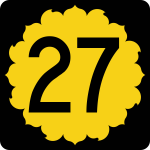
K-27
Length: 226.241 miles
South Endpoint:
Oklahoma State Line South of Elkhart (1926-1953)
OK 95 at the Oklahoma State Line south of Elkhart (1953-2003)
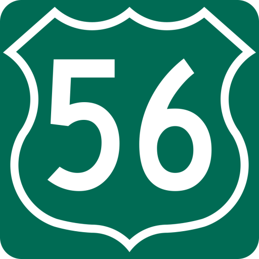
Junction US 56 northeast of Elkhart (2003-present)
North Endpoint: Nebraska State Line south of Haigler, Neb.
Counties Served:
Morton, Stanton, Hamilton, Greeley, Wallace, Sherman, Cheyenne
K-28
Length: 29.019 miles
West Endpoint:
NE 78 at the Nebraska State Line south of Guide Rock, Neb. (1926-1995)
Junction K-14 in Jewell (1995-present)
East Endpoint:
Junction K-9 west of Concordia
Counties Served: Jewell, Cloud
Junction Guide
| KDOT Milepost | Total Miles | Junction |
|---|---|---|
| 28-45/0.000 | 0.000 | K-14 (Begin K-28) |
| 28-45/0.637 | 0.637 | East city limits Jewell |
| 28-45/6.100 | 6.100 | K-148 |
| 28-45/7.592 | 7.592 | North city limits Randall |
| 28-45/8.141 | 8.141 | East city limits Randall |
| 28-45/14.080 28-15/0.000 | 14.080 | Jewell/Cloud county line |
| 28-15/6.000 | 20.080 | 40th Road, Jamestown |
| 28-15/14.939 | 29.019 | K-9 (End K-28) |
AADT (2019)
| Location | Count | Truck % |
|---|---|---|
| K-14 to East city limits Jewell | 540 | 14.8% |
| Jewell to K-148 | 370 | 6.8% |
| K-148 to Randall | 325 | 18.5% |
| Randall to Jamestown | 185 | 32.4% |
| Jamestown to K-9 | 795 | 8.2% |
K-29
Length: 14.062 miles
Historic West Endpoint: Junction K-13 near Manhattan (1926-1960)
East Endpoint: Junction K-99 east of Wabaunsee (1926-1960)
Counties Served: Riley, Wabaunsee (1926-1960)
History
The highway along the south side of the Kansas River southeast of Manhattan was originally numbered K-29 in the final version of the original highway numbering plan as part of a rough clustering pattern for shorter route segments. The Riley county segment of the road was graveled by 1928 and the Wabaunsee County segment was graveled by 1938. Except for a short segment on the west end of the route near Manhattan, the route was not hard-surfaced until 1953. The designation was changed to K-18 around 1960.
K-30
Length: 1.950 miles
South Endpoint: I-70 exit 341
North Endpoint: South city limits of Maple Hill
County Served: Wabaunsee
AADT (2019): 1,380 (6.2% truck)
History
Origionally, K-10 served the town of Maple Hill. In 1941, a new alignment bypassed Maple Hill, leading to the State Highway commission adding a new spur route. The spur was designated in a July 8, 1941 resolution. The number was ‘backfilled,’ the number having previously been withdrawn in 1937. The road consisted of a existing gravel county road. It was paved by 1953.
K-30 (1926)
Historic West Endpoint: Junction K-4 near Rock Creek
Historic East Endpoint: Junction US 40 in Tonganoxie
Historic Counties Served: Jefferson, Leavenworth
History
The highway from Rock Creek to Tonganoxie via Oskaloosa an McLouth was originally numbered K-30 in the final version of the original highway numbering plan as part of a rough clustering pattern for shorter route segments. It’s route was divided between two routes – K-92 west of Oskaloosa, K-24 east of McLouth – by 1932.
K-30 (1933)
Historic West Endpoint: Junction K-7 near Bonner Springs
Historic East Endpoint: Junction US 40 near Kansas City
Historic Counties Served: Wyandotte
History
This iteration of K-30 may be related to the Rock Creek-Tonganoxie route; however, at this time, I am listing the two routes seperatly.
This version of K-30 was designated along what is now State Avenue between today’s 126th and 38th Streets. This was likely a temporary designation used during the construction of a four-lane highway along State Avenue. When the State Avenue project was completed in 1937, it was designated US 24–40
K-32
Length: 32.361 miles
West Endpoint: Junction US 24–40 east of Lawrence
East Endpoint: Junction US 69 in Kansas City
Counties Served: Douglas, Leavenworth, Wyandotte
Junction Guide
| KDOT Milepost | Total Miles | Junction |
|---|---|---|
| 32-23/0.000 | 0.000 | US 24/US 40 (begin K-32) |
| 32-23/0.164 32-52/0.000 | 0.164 | Douglas/Leavenworth county line |
| 32-52/5.228 | 5.392 | 222nd Street |
| 32-52/7.988 | 8.152 | West city limits Linwood |
| 32-52/8.125 | 8.289 | East city limits Linwood |
| 32-52/17.009 32-105/0.000 | 17.173 | Leavenworth/Wyandotte county line West city limits Bonner Springs |
| 32-105/1.569 | 18.742 | Cedar Ave/Front St |
| 32-105/2.108 | 19.281 | K-7 |
| 32-105/2.788 | 19.961 | 121st Street |
| 32-105/3.630 | 20.803 | Bonner Springs/Edwardsville city limits |
| 32-105/6.583 | 23.756 | I-435 |
| 32-105/6.785 | 23.958 | Edwardsville/Kansas City city limits |
| 32-105/11.187 | 28.360 | Turner Diagonal |
| 32-105/12.129 | 29.302 | 55th Street |
| 32-105/13.478 | 30.651 | I-635 |
| 32-105/15.188 | 32.361 | US 69 (end K-32) |
AADT (2019)
| Location | Count | Truck % |
|---|---|---|
| US 24-40 to 222nd Street | 2,200 | 10.5% |
| 222nd Street to Linwood | 2,600 | 8.5% |
| In Linwood | 3,140 | 7.3% |
| Linwood to Bonner Springs | 3,770 | 6.5% |
| WCL Bonner Springs to Cedar Ave/Front St | 5,030 | 21.8% |
| Cedar Ave/Front St to K-7 | 10,200 | 7.6% |
| K-7 to 121st Street | 11,400 | 9.9% |
| 121st Street to I-435 | 14,700 | 7.9% |
| I-435 to Turner Diagonal | 17,700 | 8.3% |
| Turner Diagonal to 55th Street | 15,700 | 9.6% |
| 55th Street to I-635 | 18,400 | 8.2% |
| I-635 to US 69 | 10,700 | 10.6% |
K-32 Truck Route
(Bonner Springs)
West Endpoint:
Junction K-32 at Kump Avenue/Scheidt Lane intersection.
East Endpoint:
Junction K-32 at Ceder Street/Front Street intersection.
County Served: Wyandotte
K-33
Length: 10.425 miles
South Endpoint:
Junction K-31 near Waverly (1926-1936)
Junction K-68 south of Wellsville (1936-present)
North Endpoint: Junction US 56 north of Wellsvile
Counties Served: Franklin, Douglas
Historic Counties Served: Coffey (1926-1936)
Junction Guide
| KDOT Milepost | Total Miles | Junction |
|---|---|---|
| 33-30/0.000 | 0.000 | K-68 (begin K-33) |
| 33-30/4.355 | 4.355 | Riley Road |
| 33-30/6.044 | 6.044 | I-35 |
| 33-30/6.389 | 6.389 | South city limits Wellsville |
| 33-30/7.409 | 7.409 | North city limits Wellsville |
| 33-30/8.405 33-23/0.000 | 8.405 | Franklin/Douglas county line |
| 33-23/2.020 | 10.425 | US 56 (end K-33) |
AADT (2019)
| Location | Count | Truck % |
|---|---|---|
| K-68 to Riley Road | 1,570 | 3.8% |
| Riley Road to I-35 | 2,610 | 2.5% |
| I-35 to Wellsville | 5,130 | 2.7% |
| Wellsville to US 56 | 1,730 | 7.5% |
K-34
Length: 29.260 miles
South Endpoint:
OK 34 at Oklahoma State Line south of Sitka (1937-1940)
Oklahoma State Line south of Sitka, concurrent with US 183 (1940-1994)
Junction US 160-183 north of Sitka (1994-present)
North Endpoint: Junction US 400 northwest of Bucklin
Counties Served: Clark, Ford
Historic Counties Served: Comanche
History
In 1937, the State Highway Commission accepted control of a road in Clark County connecting Oklahoma Highway 34 with US 160 near Sitka and designated it as K-34. In addition, they changed the designation of the road between Protection and Bucklin from K-41 to K-34, while the old K-34 in southeast Kansas was re-designated K-37. By 1940, the road between Sitka and the Oklahoma line was designated as US 183. By 1965, a new alignment for K-34 was built between Bucklin and Sitka, bypassing Protection and Comanche County.
The segment from the Oklahoma state line to US 160 was co-designated as US 183/K-34 until 1994, when the K-34 designation was removed.
Junction Guide
| KDOT Milepost | Total Miles | Junction |
|---|---|---|
| 34-13/0.000 | 0.000 | US 160/US 183 (begin K-34) |
| 34-13/8.068 | 8.068 | County Road M |
| 34-13/19.614 34-29/0.000 | 19.614 | Clark/Ford county line |
| 34-29/5.402 | 25.016 | South City limits Bucklin |
| 34-29/5.914 | 25.528 | East junction US 54 |
| 34-29/6.035 | 25.649 | West junction US 54 |
| 34-29/6.306 | 25.920 | West city limits Bucklin |
| 34-29/9.646 | 29.260 | US 400 (end K-34) |
AADT (2019)
| Location | Count | Truck % |
|---|---|---|
| US 160/US 183 to County Road M | 720 | 25.0% |
| Clark County Road M to MP 19 | 695 | 27.3% |
| MP 19 to Bucklin | 775 | 31.6% |
| South city limits Bucklin to east junction US 54 | 1,510 | 16.2% |
| US 54/K-34 concurrency | 5,810 | 27.5% |
| West junction US 54 to west city limits Bucklin | 1,600 | 19.7% |
| Bucklin to US 400 | 1,290 | 23.3% |
K-34 (1926)
Historic West Endpoint:
Junction K-96 near LaFontaine
North Endpoint: Junction US 169 south of Thayer
Historic County Served: Wilson
History
The highway from LaFontaine to Thayer was originally numbered K-34 in the final version of the original highway numbering plan as part of a rough clustering pattern for shorter route segments. It was re-designated as a realignment of K-96 from LaFontaine to Neodesha and the remainder was re-designated K-37 in 1937 as part of a sequence of re-numberings to allow the number 34 to be assigned to a new route in Clark County.

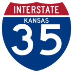
I-35
Length: 235.403 miles
South Endpoint:
Oklahoma State Line South of South Haven
North Endpoint:
Missouri State Line in Kansas City
Counties Served:
Sumner, Sedgwick, Butler, Chase, Lyon, Coffey, Osage, Franklin, Miami, Johnson, Wyandotte
I-35W
West Endpoint:
I-35 exit 42 in Wichita
East Endpoint:
I-70 exit 250 in Salina
Counties Served:
Sedgwick, Harvey, McPherson, Saline (1957-1977)
K-35
Length: 12.175 miles
Historic West Endpoint:
Junction K-7 near Beagle (1927-1937)
Junction K-7 west of La Cygne (1937-1957)
Historic East Endpoint: Junction US 69 east of La Cynge
Historic Counties Served: Miami (1927-1937), Linn (1927-1957)
History
The highway from Beagle to La Cynge was originally numbered K-35 in the final version of the original highway numbering plan as part of a rough clustering pattern for shorter route segments. Upon the creation of the State Highway system in 1927, all of K-35 was dirt. By 1930, the segment from La Cynge west to the Linn/Miami county line was graveled. By 1932, the segment from La Cynge east to US 73E was hard-surfaced.
In January 1937, K-35 was realigned to the south, meeting K-7 in Linn County near Parker. The segment west of La Cynge did not get hard-surfaced until 1956.
In anticipation of the new Interstate 35, K-35 was re-designated K-135 on October 31, 1957. It was subsequently re-designated K-152, its present designation, in March of 1977.
US 36
Length: 390.594 miles
West Endpoint:
Junction US 40N near Halford, concurrent with K-22 (1926-1930)
Colorado State Line west of St. Francis (1930-present)
East Endpoint:
Missouri State Line at Elwood, Kan./St. Joseph, Mo.
Counties Served:
Cheyenne, Rawlins, Decatur, Norton, Phillips, Smith, Jewell, Republic, Washington, Marshall, Nemaha, Brown, Doniphan
Historic Counties Served: Thomas, Sheridan (1926-1930)
K-37
Length: 12.613 miles
Historic West Endpoint: Junction US 75 near Neodesha
Historic East Endpoint: Junction US 160/US 169 south of Thayer
Historic Counties Served: Wilson, Montgomery (1937-1998)
History
K-37 was established in southeast Kansas as a re-designation of K-34 in 1937 as part of a re-numbering sequence to allow the number 34 to be used for a new highway in Clark County. K-37 was removed from the state highway system and turned back to the counties in 1998 when US 400 was opened on a new alignment nearby.
K-37 (1926)
Historic Southwest Endpoint: Junction US 50S in Kinsley
Historic Northeast Endpoint:
Junction K-8 near Seward (1926-1932)
Junction US 50N in Larned (1932-1936)
Historic Counties Served:
Stafford (1926-1932)
Edwards, Pawnee, (1926-1936)
History
The highway from Kinsley to Seward was originally numbered K-37 in the final version of the original highway numbering plan as part of a rough clustering pattern for shorter route segments. The route between US 50N at Larned, and K-8 at Seward was re-designated as an extension of K-19 by 1932. The segment from Seward to Larned became an K-45 by 1937 as part of a re-numbering sequence to allow the K-34 designation to be used in Clark County.
K-38
Length: 12.731 miles
Historic West Endpoint: Junction K-15 north of Dexter
Historic East Endpoint: County Road 2 north of Cloverdale
Historic Counties Served: Cowley, Chautauqua (1937-1997)
History
Originally, K-38 was part of a proposed shortcut from Winfield to Independence which never materialized. The segment that was built was completed by 1945 and paved by 1950. No additional extension of K-38 was completed. Cowley County agreed to take over maintenance of K-38 in the 1990s in consideration for building a US 77 bypass at Arkansas City. K-38 was removed from the state system in November of 1997, when the Arkansas City bypass was completed.
K-38 (1926-1936)
West Endpoint: Junction K-6 in Kincaid
East Endpoint: Junction US 73E at Fulton
Historic Counties Served:
Anderson, Linn, Bourbon (1926-1936)
K-39
Length: 65.032 miles
West Endpoint:
Junction K-96 north of Fredonia (1926-1937)
Junction US 160 near Elk City (1937-1998)
Junction US 400 northwest of Fredonia (1998-present)
East Endpoint: Junction K-7 east of Hiattville
Counties Served: Wilson, Neosho, Bourbon
Historic County Served: Montgomery (1937-1998)
Junction Guide
| KDOT Milepost | Total Miles | Junction |
|---|---|---|
| 39-103/0.000 | 0.000 | US 400 (begin K-39) |
| 39-103/14.821 | 14.821 | West junction US 75 |
| 39-103/15.749 | 15.749 | East junction US 75 |
| 39-103/23.755 39-67/0.000 | 23.755 | Wilson/Neosho county line |
| 39-67/2.534 | 26.289 | US 169 |
| 39-67/2.913 | 26.668 | West city limits Chanute |
| 39-67/4.979 | 28.734 | East city limits Chanute |
| 39-67/15.334 59-67/20.922 | 39.089 | West Junction US 59 |
| 59-67/26.096 | 44.263 | Old K-201, Stark |
| 59-67/28.107 39-67/22.519 | 46.274 | East Junction US 59 |
| 39-67/26.520 39-6/0.000 | 50.275 | Neosho/Bourbon county line |
| 39-6/5.971 3-6/3.514 | 56.246 | West junction K-3 |
| 3-6/3.010 39-6/6.475 | 56.750 | East junction K-3 |
| 39-6/14.757 | 65.032 | K-7 (end K-39) |
AADT (2019)
| Location | Count | Truck % |
|---|---|---|
| US 400 to MP 4 | 615 | 50.4% |
| MP 4 to MP 10 | 1,150 | 26.1% |
| MP 10 to US 75 | 1,080 | 27.3% |
| US 75/K-39 concurrency | 3,030 | 23.8% |
| US 75 to Wilson/Neosho County line | 2,030 | 15.8% |
| Wilson/Neosho County line to US 169 | 3,030 | 10.9% |
| US 169 to Chanute | 3,610 | 7.2% |
| In Chanute | 6,330 | 5.1% |
| Chanute to MP 33 | 2,350 | 11.1% |
| MP 33 to west junction US 59 | 1,620 | 11.4% |
| US 59 from west junction US 59/K-39 to Stark | 1,180 | 25.0% |
| US 59 from Stark to east junction US 59/K-39 | 1,260 | 23.0% |
| East junction US 59 to MP 51 | 695 | 10.1% |
| MP 51 to west junction K-3 | 590 | 11.0% |
| K-3/K-39 concurrency | 735 | 20.4% |
| East junction K-3 to K-7 | 700 | 9.3% |

